At the Smart Geospatial Solutions Conference 2017 Paulina Lachowska and Szymon Gutkowski from innogy gave a presentation “From network infrastructure to business processes”. Paulina and Szymon indicated how EL.GIS system supported innogy over the years. During this time network documentation went from paper through CAD drawings to version 3.2 of Smallworld EL.GIS system, implemented at innogy (RWE Stoen) over 15 years ago. In March 2017 our team upgraded EL.GIS system to version 4.3.
EL.GIS system at innogy
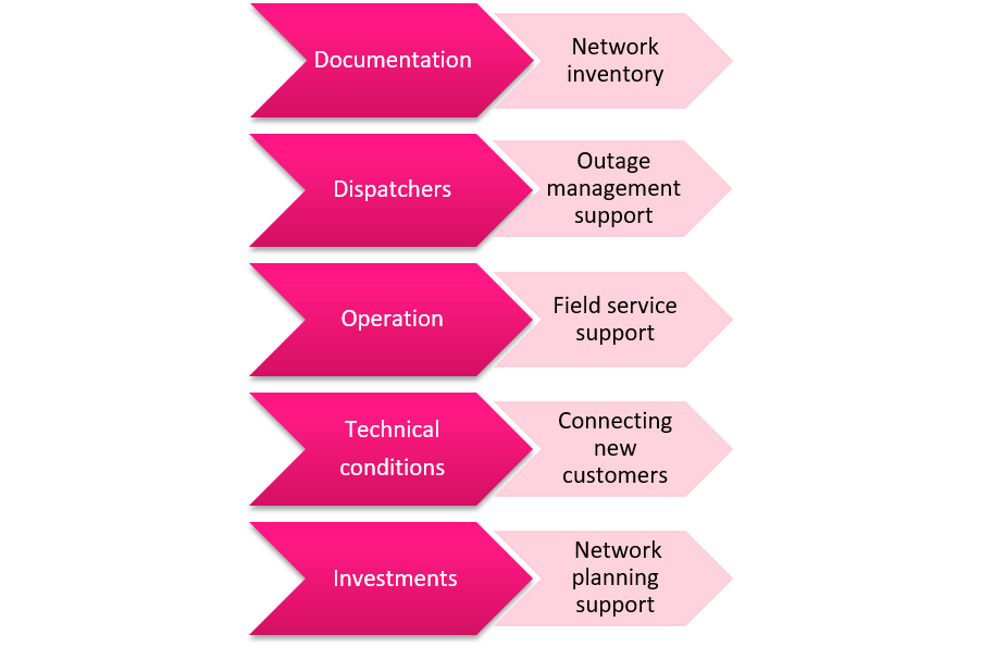
EL.GIS system supports key business processes of the company. The system provides means to visualize location of new customers (along with the location of their power supply) which helps establishing technical conditions for their connection. EL.GIS supports also the whole process of investment, including: planning, cost estimation and preparing all the necessary documentation. Dispatchers use EL.GIS to organize engineering and business activities around a network outage. Thanks to EL.GIS field teams have access to network data on mobile devices (using Smallworld thin-client: Network Viewer). The network data is updated in the system by the documentation department.

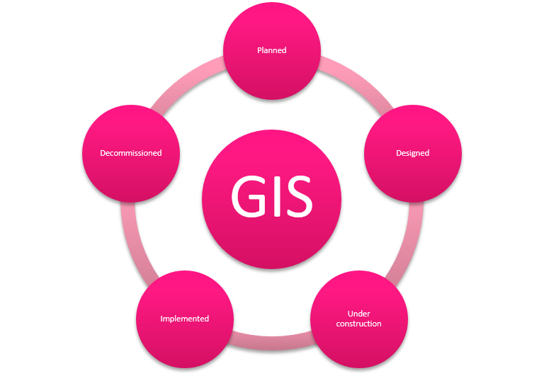
All these processes require to set the life cycle for each data collection. At innogy this is managed by assets’ statuses defined for all stages: planning, designing, connecting and decommissioning.

To ensure proper data flow and business process support network assets data must be consistent between different systems. To achieve this it’s necessary to define “the master” system (data owner) for each integration. The master overrides other systems. Currently, EL.GIS is integrated with BPM to display and view technical documentation in ADX (documentation management) as well as real estate documentation (ADSn). What’s more, EL.GIS integration with SCADA system is now going live!
Implementation of LV and MV network investment
Paulina and Szymon discussed an examplary process “Implementation of LV and MV network investment” and indicated the role of EL.GIS system. One of the first steps here is to develop an investment plan and to make a budget. At this stage EL.GIS provides means to estimate the size of the investment. Then the project documentation is developed (location of new assets, activation etc.). After the design and construction stages it’s time to power up the new assets. This is where the Submission Document begins. The document is a basis for changing status of new assets in GIS system. In the end, the documentation department verifies attributes in GIS and BPM ADX – a system for storing digital documents.
Paulina and Szymon highlighted that EL.GIS system supports the whole organization by enabling:
- on-site and off-site access to the application
- to store data from distributed databases within a single tool
- integration with other systems
- business processes support.
About innogy Group
The innogy Group is a leading European energy company operating in the areas of renewable energy, electricity and gas grid infrastructure. The key markets of the company are: Germany, the UK, the Netherlands, Belgium, Poland, the Czech Republic, Slovakia, and Hungary.
More: https://iam.innogy.com/en/ueber-innogy


